Fillmore Basin FAQ Sheet
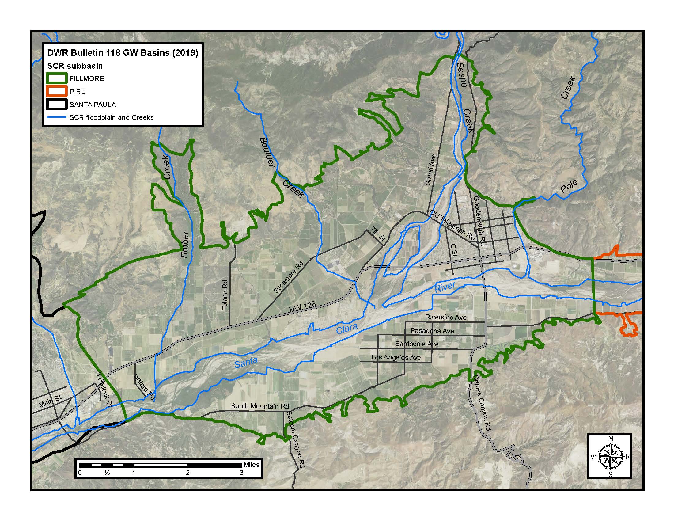
The Fillmore basin is one of a series of alluvial groundwater basins (sub-basin) located along the Santa Clara River Valley in Ventura County, California; and is within the Santa Clara River Watershed and fully within Ventura County. The City of Fillmore is within the Fillmore basin, but the predominant land use is agricultural.
The Fillmore basin is contiguous with and lies west of the Piru basin. The basin extends northward to include the Pole Creek fan and the greater floodplain of Sespe Creek, extending approximately four miles north of Highway 126. The western boundary of the Fillmore basin is located approximately at Willard Road, which is just east of the City of Santa Paula and is distinguished by an area of rising groundwater (a gaining reach of the river). The surface area of the Fillmore basin is approximately 21,700 acres.
Fillmore basin average and median water year precipitation from 1957 to 2015 was 18.32 inches and 16.05 inches respectively, as recorded at the Fillmore Fish Hatchery (station 171) near the Piru-Fillmore basin boundary. Average annual groundwater extractions for Fillmore basin from 1980 through 2015 were approximately 44,600 acre-feet.
The northern portion of the Fillmore basin located west of Sespe Creek is called the Sespe Upland. The Sespe Upland is characterized by steep south-sloping alluvial fan material, including complex terrace deposits, older alluvial fan deposits and recent alluvial fan deposits, which unconformably overlie the Pleistocene San Pedro formation (Mann, 1959).
The Pole Creek Fan is located between Sespe Creek and the Santa Clara River, and forms the northeastern portion of the basin underlying much of the City of Fillmore. This area is primarily composed of alluvial fan material.
The area of the Fillmore basin located south of the Santa Clara River is covered by recent sand and gravel deposits from the Santa Clara River and Sespe Creek. The recent sand and gravel of the Santa Clara River near the Fillmore Fish Hatchery at the eastern boundary of the basin extend to a depth of about 60 feet and the older alluvial materials extend from depths of approximately 60 to 100 feet. In the Bardsdale area, the combined thickness of this alluvial fill is as much as 120 feet (Mann, 1959). At the downstream basin boundary near Willard Road, the recent alluvium is approximately 80 feet thick. West of the City of Fillmore, the recent alluvium of Sespe Creek is approximately 80 feet thick. The recent sand and gravel deposits associated with Sespe Creek and the Santa Clara River are extremely permeable.
The San Pedro formation underlies most of the Fillmore basin and is folded into a syncline with an east-west oriented axis. Along the main axis of the syncline near the center of the basin, the San Pedro formation reaches a depth of 8,430 feet (Mann, 1959). The depth from which groundwater production is suitable for agricultural and urban use and can be reasonably extracted is considerably shallower than 8,430 feet. Few wells in the basin are deeper than 800 feet in the Fillmore basin. At the western basin boundary, the San Pedro formation extends to a depth of 5,000 to 6,000 feet.
The two principle faults that bound the Fillmore basin are the Oak Ridge fault to the south and the San Cayetano fault to the northeast. Several other faults bound the basin on the northwest side.
The Santa Clara River and Sespe Creek cut through the Fillmore basin. These and underflow from Piru basin are the major sources of recharge to the Fillmore basin. Structural or stratigraphic barriers that might impede recharge from either the Santa Clara River or Sespe Creek have not been identified.
Groundwater flow in the Fillmore basin generally moves east-to-west through the alluvium. Groundwater recharge from Sespe Creek generally flows towards the southwest. The basin is considered to be an unconfined groundwater basin.
Near the Fillmore and Santa Paula basin boundary exists another reach of the Santa Clara River that displays perennial rising groundwater (gaining stream conditions) even in dry years. The length of the gaining stream reach is greatest when water levels are high in the Fillmore and Santa Paula basins and decreases as water levels fall in the Fillmore basin.
Citation: Mann, 1959, John F. Mann Jr. & Associates, A plan for groundwater management for United Water Conservation District, 116-124p.
Events Calendar
Calendar of Events
|
M
Mon
|
T
Tue
|
W
Wed
|
T
Thu
|
F
Fri
|
S
Sat
|
S
Sun
|
|---|---|---|---|---|---|---|
|
0 events,
|
0 events,
|
0 events,
|
0 events,
|
0 events,
|
0 events,
|
0 events,
|
|
0 events,
|
0 events,
|
0 events,
|
0 events,
|
0 events,
|
0 events,
|
0 events,
|
|
0 events,
|
0 events,
|
0 events,
|
0 events,
|
0 events,
|
0 events,
|
0 events,
|
|
0 events,
|
0 events,
|
0 events,
|
1 event,
|
0 events,
|
0 events,
|
0 events,
|
|
0 events,
|
0 events,
|
0 events,
|
0 events,
|
0 events,
|
0 events,
|
0 events,
|

