Piru Basin FAQ Sheet
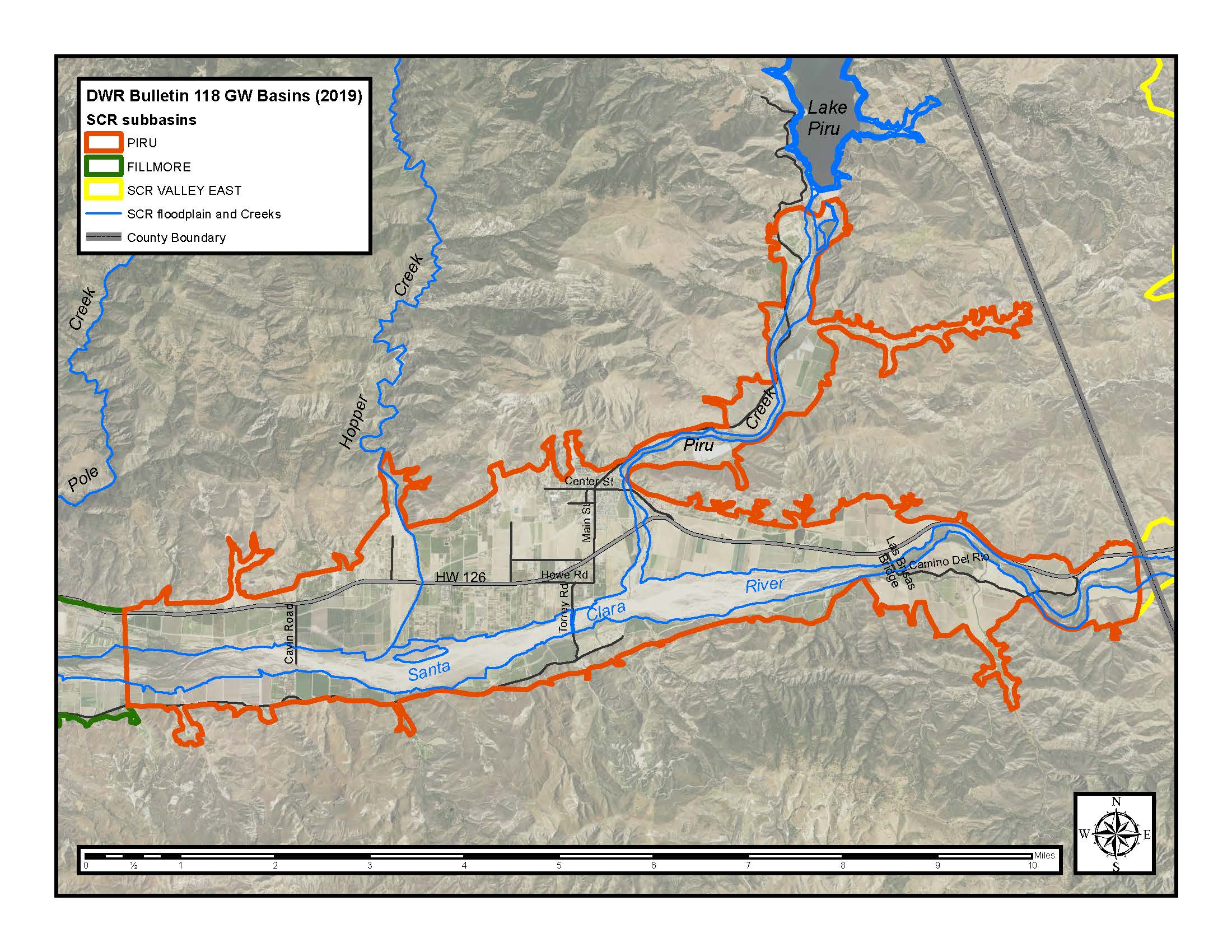
The Piru basin is one of a series of alluvial groundwater basins (sub-basin) located along the Santa Clara River Valley in Ventura County, California; and is within the Santa Clara River Watershed and fully within Ventura County. The town of Piru is within the Piru basin, but the predominant land use is agricultural.
The eastern boundary of the Piru basin is less than 1,000 feet west of the Ventura/Los Angeles County Line. The western boundary of the Piru basin is located approximately two miles upstream of the City of Fillmore upstream of the Fillmore Fish Hatchery. The topographic narrows in this vicinity result in a gaining reach of the Santa Clara River. The Piru groundwater basin covers a surface area of approximately 8,900 acres.
Piru basin average (mean) and median water year precipitation from 1950 to 2015 was 20.01 inches and 17.08 inches respectively, as recorded at the Piru-Temescal Guard Station at Lake Piru (Ventura County station 160). Average annual groundwater extractions for Piru basin from 1980 through 2015 were approximately 12,400 acre-feet.
The Piru basin consists of recent and older alluvium underlain by the Pleistocene San Pedro formation. The recent and older alluvium exists almost basin-wide and is made up primarily of coarse sand and gravel. The recent alluvium ranges in thickness from approximately 20 feet near Blue Cut at the east end of the basin to 60-80 feet in the remainder of the basin. The older alluvium occurs as terrace deposits and as a layer of variable thickness (up to 80 feet) under the recent alluvium (Mann, 1959).
The San Pedro Formation is folded into a syncline with an east-west oriented axis and underlies the older alluvium, except at the east end of the basin where the older alluvium is underlain by impermeable Pico formation. The San Pedro formation consists primarily of permeable sand and gravel and can extend to a depth of approximately 8,800 feet, as interpreted from oil well electrical logs (Mann, 1959). The depth from which groundwater production is suitable for agricultural and urban use and can be reasonably extracted is however considerably shallower than 8,800 feet. Few water wells deeper than 700 feet exist in the Piru basin.
Three principal faults bound the Piru basin: the Oak Ridge fault to the south, and the San Cayetano and Camulos faults to the north.
The channel of the Santa Clara River lies along the southern margins of the Piru basin. Downstream of Las Brisas Bridge, near the east end of the basin, the channel begins to broaden significantly. The percolation of surface water in the channel of the Santa Clara River is the largest source of recharge to the Piru basin. There are no known structural or stratigraphic barriers impeding recharge from the Santa Clara River.
Groundwater flow in the alluvium of the Piru basin tends to be westerly, parallel to the river channel. Similarly, groundwater flow in the San Pedro formation is generally westerly with a small northerly and southerly components. Clay layers have been identified at some locations within the basin but are not thought to be continuous. The basin is considered to be an unconfined groundwater basin.
The reach of the Santa Clara River within the topographic narrows located about one mile upstream from the City of Fillmore (and near the Fillmore Fish Hatchery) displays perennial rising groundwater (a gaining stream reach) in all but the very driest of years. The gaining stream reach extends upstream to the vicinity of Hopper Creek when the Piru basin is full and contracts downstream towards the Fillmore Fish Hatchery in Fillmore basin as water levels fall within in the basin.
Citation: Mann, 1959, John F. Mann Jr. & Associates, A plan for groundwater management for United Water Conservation District, 116-124p.
Events Calendar
Calendar of Events
M Mon
T Tue
W Wed
T Thu
F Fri
S Sat
S Sun
0 events,
0 events,
0 events,
0 events,
0 events,
0 events,
0 events,
0 events,
0 events,
0 events,
0 events,
0 events,
0 events,
0 events,
0 events,
0 events,
0 events,
1 event,
0 events,
0 events,
0 events,
0 events,
0 events,
0 events,
0 events,
0 events,
0 events,
0 events,
0 events,
0 events,
0 events,
0 events,
0 events,
0 events,
0 events,
- There are no events on this day.
- There are no events on this day.
- There are no events on this day.
- There are no events on this day.
- There are no events on this day.
- There are no events on this day.
- There are no events on this day.
- There are no events on this day.
- There are no events on this day.
- There are no events on this day.
- There are no events on this day.
- There are no events on this day.
- There are no events on this day.
- There are no events on this day.
- There are no events on this day.
- There are no events on this day.
- There are no events on this day.
- There are no events on this day.
- There are no events on this day.
- There are no events on this day.
- There are no events on this day.
- There are no events on this day.
- There are no events on this day.
- There are no events on this day.
- There are no events on this day.
- There are no events on this day.
- There are no events on this day.
- There are no events on this day.
- There are no events on this day.
- There are no events on this day.
- There are no events on this day.
- There are no events on this day.
- There are no events on this day.

